


Rando velo Inishmore 40 km

jeanmarcMasson
Gebruiker GUIDE
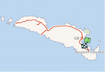

Lengte
40 km

Max. hoogte
77 m

Positief hoogteverschil
429 m
Km-Effort
45 km

Min. hoogte
-1 m

Negatief hoogteverschil
421 m
Boucle
Neen
Datum van aanmaak :
2024-06-26 08:59:06.586
Laatste wijziging :
2024-06-26 17:35:51.606
4h27
Moeilijkheid : Zeer moeilijk

Gratisgps-wandelapplicatie
 SityTrail
IGN / Geografische instituten
SityTrail Plus
De wereld gaat voor u open
Over ons
Tocht Fietstoerisme van 40 km beschikbaar op Onbekend, County Galway, Conamara Municipal District. Deze tocht wordt voorgesteld door jeanmarcMasson.
Plaatsbepaling
Land:
Ireland
Regio :
Onbekend
Departement/Provincie :
County Galway
Gemeente :
Conamara Municipal District
Locatie:
Árainn
Vertrek:(Dec)
Vertrek:(UTM)
455339 ; 5884469 (29U) N.
Opmerkingen